Messages are welcome on any subject relating to Troopers Hill Local Nature Reserve; the surrounding area of St George and Crews Hole or any of Bristol's Parks and Green Spaces.
Friends of Troopers Hill Forum - www.friends-forum.org.uk
|
||
| Return to Website | ||
 First First |
 Prev Prev |
 Reply Reply |
 Forum Forum |
Next  |
Last  |
| Viewing Page 1 of 1 (Total Posts: 6) |
| Author | Comment |
Roger

 Apr 15, 07 - 9:23 PM |
The lower stack, a book and my confusion :)
In the book "Crews Hole, St George and Speedwell"-ISBN - 7524-2948-5 it's easilly available, and possibly many of you have it... Anyway, pages 28 and 29 have been worrying me, lets start with page 29 a photoof the lower stack, pretty much as we know it today, on page 28 there is a drawing by Samuel Loxton, apparently showing the engine house, it just seems to be on a road and not on a corner. Have the roadways changed that much, is the drawing displaying 'artistic licence'? More confusion for me with the upper photoon page 28 'coal digging on Troopers Hill' well. that looks like Loxtons engine house in the background, similar context for sure. Where is crews hole road? For me it seems that saying Loxons drawing is of the engine house is wrong, in fact that drawing seems more likely to be of a domestic property. Was the engine house converted for domestic use later? I can bring the book to Wednesdays meeting if it helps someone to explain it to me. |
|
Rob
Apr 15th, 2007 - 9:53 PM |
Roger, I'm not surprised you are confused - it took me a while to sort it out. The caption on the Loxton drawing is wrong. It is actually the same building as you see in the coal digging photo and was part way up Troopers Hill Rd. The chimney at the corner of Troopers Hill Road and Crews Hole Rd was attached to another probably indentical building. Both were engine houses for Troopers Hill Colliery. As was usually the case there were two shafts for the mine and an engine house for each. To ensure ventilation the air is made to circulate with one shaft as the downdraft and one as the updraft. The colliery opened in the early 1800s, probably about 1820, it was closed by 1845. As you say the Loxton drawing appears to show the upper one as having been converted for residential use. The lower one is still shown as an engine house in an 1886 lease, so it maybe that it was kept in operation in some way after the mine closed, perhaps someone out there can enlighten us? As you say it is an excellent book and anyone with a interest in the area should buy it. |
|
Roger
Apr 15th, 2007 - 10:05 PM |
Thanks saving my sanity rob , any idea where the upper engine house was ? Are there any images of the lower one ? |
|
Rob
Apr 15th, 2007 - 10:32 PM |
I've never seen any images of the lower engine house, I would be very pleased if anyone could find one. This photo will help you identify the location, it is as near to the same view as I could get. The house with the two gable ends - one now white and the other stone - is clearly visible in both the Loxton Drawing and the Coal digging photo. |
|
Roger
Apr 15th, 2007 - 11:15 PM |
Any reason to think that the lower engine house had a different design to the upper one, allthough, I guess neither any reason to suggest it was the same. Incidentally, was Loxton contemporary or not, can't seem to find lots about him. Roger |
|
Roger
Apr 16th, 2007 - 1:03 PM |
I found the 1902 map of St. George in the bookshop today and had a look to see if I could at least see if the layout of the lower stack (building) was similar to the upper one. Unfortunately the map does not cover the lower stack, missed off by a few tens of yards. 
|
| First |
Prev |
Reply |
Forum |
Next |
Last |
 bravenet.com
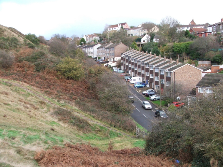